Da peerie trip to Shetland
Written on 11th June 2015 | No Comments
I’ve recently returned from a trip to Shetland, staying with my friends Marc and Rae. Marc’s working on his PhD titled “Shetland Boat: History; Folklore and construction” so he was a great source of information about the history of the islands and the part that fishing and boats have played.
Shetland has over 1,600 miles of coastline which is spread over about 300 islands of various sizes. It’s fair to say that the sea dominates and you’re never far from a coastal view. You might expect the landscape to be impressive and it certainly doesn’t disappoint. Its character reminded me of the remoteness of Dartmoor, the rugged coastline of Cornwall and the expansive views of the Scottish Highlands. Something that contributes to this experience is a lack of trees which allows for far reaching views unhindered by breaks to the line of sight that forest or woods cause.
Visiting in May, the weather was wonderful and while it was quite windy at times this brought ever changing skies and beautiful light. One outing to St Ninian’s highlighted this as we were dressed in several layers, including waterproofs and down, just to feel comfortable. As you might expect though, for the locals this weather only required a jumper and a hat.

In the middle of the day sparkling sunshine illuminated the islands around St. Ninian’s. The colour of the water continued to fascinate me as it would range from deep blue to turquoise, always looking inviting yet probably freezing.
On the island of West Burra we explored Sand Wick Bay. This little bay was full of interest; in the mornings seals would lie on the rocks, 15-20 at a time, soaking up the sun and watching any passer by. As the weather changed and the winds picked up waves would thunder in, the full force of the Atlantic Ocean ever-present.

Around the corner from Sand Wick Bay was a natural arch that I’d noticed on an OS map. I visited this spot a couple of times, picking one particularly windy evening (by my standards, anyway) to make this picture at dusk. I could only spend a short while here as the sea spray quickly coated my camera and filters.

Later we travelled north west of mainland Shetland to a place called Esha Ness. Esha Ness is an impressive area containing some of the most wonderful coastal stacks I’ve seen. The cliffs at the Head of Stanshi were particularly dramatic and even on a relatively calm day it was evident how powerful the force of the ocean is.

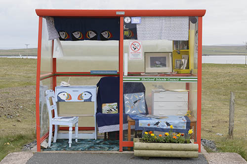
After visiting mainland Shetland we travelled to the northernmost inhabited island of Unst. The weather turned grey and wet here, making it difficult to get any pictures. One of the curious sights during our short time on Unst was the famous Unst Bus Shelter which is decorated according to a theme that changes regularly. When we visited it was all about Puffins, with books, pictures and paintings dotted around. Puzzlingly, though, we didn’t see a single bus…

Before long it was time to return home. Our outward trip by ferry from Aberdeen to Lerwick was calm but during the return trip a five metre swell made the ferry rock around. While this felt like being on a roller coaster with people being sick in front and behind it was quite a magical experience. The waves crashed around our boat as Fair Isle drifted into view. It might sound like a romanticised cliche but at that moment the clouds parted and a little light skirted along the island, making it seem all the more dramatic. A fitting end to our visit.
If you’re wondering about the title of this post, the word ‘peerie’ is used by Shetlanders to describe something small. I hope you’ve enjoyed this brief glimpse of Shetland.
Leave a comment
Categories
- Articles (16)
- Backstory (5)
- Location guides (6)
- News (5)