Crook Peak: on the edge of the Mendip Hills
Written on 1st April 2022 | No Comments
The popular depiction of Somerset is of flat countryside criss-crossed by waterways. That’s largely true, except where the land rises to form the county’s three Areas of Outstanding Natural Beauty: the Mendip Hills, the Quantock Hills and the Blackdown Hills.
The most rugged of these is the Mendip Hills, which is home to the world famous Cheddar Gorge. At their western end is the lesser known Crook Peak, yet I think it’s one of the most beautiful parts of Somerset because it features superb views of the county plus a hint of ruggedness.
Most visitors to Crook Peak will be familiar with the distinctive limestone outcrop that influences the ‘crook’ part of its name. From this relatively lofty viewpoint 191 metres above sea level – which is practically mountainous by Somerset standards – you can see the vast expanse of the Somerset Levels, with landmarks like Glastonbury Tor, Brent Knoll and the Isle of Wedmore creating focal points in the distance.

The top of Crook Peak makes a compelling photograph alone. Here the limestone of the Mendip Hills takes centre stage, jutting out in diagonal lines. If you get there early enough you can watch the first rays of the morning sun illuminate the tips of these rock formations. For me, there’s something very special about the warm, orangey light of sunrise reflecting on stone. The view looking east is my favourite because it avoids the M5 motorway and takes in the ridgeway of Wavering Down, leading to Axbridge, Cheddar Gorge and the Somerset Levels beyond.

This was the first view of Crook Peak that I photographed and I have since spent a lot of time exploring the landscape surrounding it. A short distance east, following the West Mendip Way footpath, is Wavering Down. Limestone outcrops are still noticeable here but far less obvious. One of my favourite views from Wavering Down is almost at the top of the hill where a small formation of limestone breaks through the otherwise smooth surface of grass on the hillside. This view sets Crook Peak in the context of the surrounding hills. Being a westerly view, I prefer to photograph it at sunset or late in the afternoon when the light is intense.

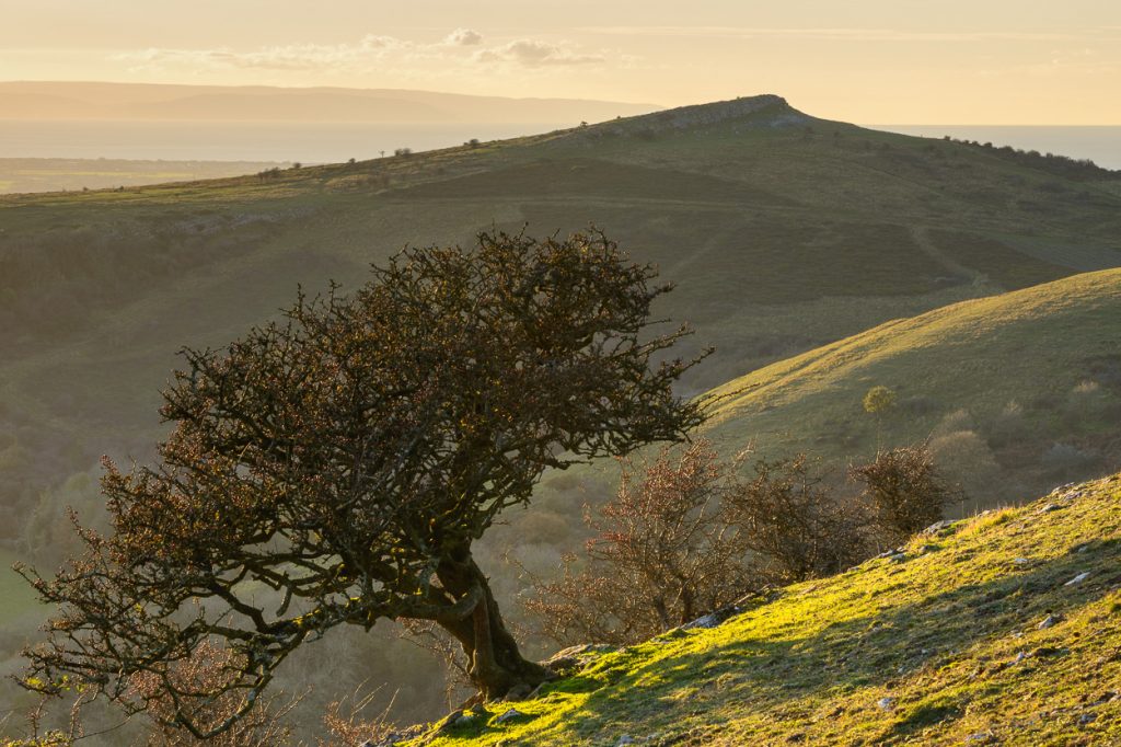
I was sure that there was more to Crook Peak than its limestone outcrops so I started exploring what else was inspiring in the area. I’m often drawn to interesting trees and a lone Hawthorn caught my eye during one of my wanders off the beaten path. I like the way it seems to hug the hillside, alluding to the gradient of the land. Trees are seasonal markers and I found it interesting to visit in autumn and summer, to see the difference in foliage and colour.

The views south from Wavering Down are worthy of a mention in their own right because they are so expansive. On a clear day it’s possible to make out the Quantock and Blackdown Hills on the horizon, which are over 16 miles away. Because the landscape is so flat, the sky can seem bigger here. It’s a great place from which to watch passing clouds and weather patterns.

After exploring much of the area immediately surrounding Crook Peak I grew interested in how it might look from further afield. This is where scouting for views takes time; where does one start? A good place is an Ordnance Survey map, which shows both the visible undulations of the land and the invisible treasures such as historic settlements, standing stones and earthworks. It was the first of these that drew my eye to a spot near Banwell. The site of a Roman settlement, it seemed the perfect viewpoint as it was elevated and publicly accessible. As an aside, I’ve noticed a correlation between roman settlements and beautiful scenery. I’d be surprised if the Romans’ decision to build here wasn’t influenced by its commanding view of the Mendip Hills and, most prominently, Crook Peak itself. The other good thing about such locations is that they’re often protected and unspoilt.

Although this concludes my little tour of Crook Peak, I’m not done exploring yet. There are many surrounding hills and fields from which to view this part of the Mendip Hills and I want to capture them.
For now though, I’ll leave you with an abstract view. It was taken from the slopes of Crook Peak on a wonderfully misty morning in October. Although the landscape here is flat, the mist formed its own undulations to create an ethereal scene.
To purchase any of these photographs, browse my gallery for prints of Crook Peak and prints of the Mendip Hills.

Leave a comment
Categories
- Articles (16)
- Backstory (5)
- Location guides (6)
- News (5)